Geophysics and Oil & Gas
Geophysics
Whether it is to measure the ground conductivity, or to determine the position of a downhole tool, magnetic and electromagnetic measurements are commonly used in geophysics applications.
Both vector and scalar magnetometers find a use in geophysics, and within the vector magnetometers fluxgate are more widely used due to their relatively small size, low power consumption and ability to operate at ambient temperature.
Recorded webinar: Long Term Magnetic Field Monitoring for Space Weather Monitoring and GIC Forecasting
Time-Domain EM – TDEM
TDEM is commonly used to estimate underground resistivity and is useful for mapping of mineral ores. Generally, induction coils are used as receivers due to their wider bandwidth. However, when working with highly conductive targets, the secondary magnetic fields to be measured are decaying extremely slowly at rates where fluxgate sensors become more sensitive than induction coils.
Here the most critical point is to ensure that the fluxgate has the lowest noise possible. The Mag-13MSQ or Mag-13MSZ are ideal with noise down to <5pTrms or <4pTrms respectively.
Airborne Magnetics
The mapping of magnetic field from an airborne platform is used for mineral exploration, UXO (unexploded ordnance) detection and mapping of buried metal structures, or even archaeology. For manned aircraft, the fluxgate sensor is used to perform airframe correction on the scalar magnetometer data. For unmanned applications, total field correction of the fluxgate sensor allows for it alone to be used for the survey.
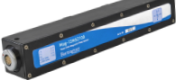
In both cases, low noise is essential and the Mag-13MSL or Mag-13MSQ will respond to this need. They also offer low orthogonality errors. For ease of integration, the Mag658 digital magnetometer may be used.
Magnetotellurics – MT
This EM (electromagnetic) method is used in a variety of context from exploration to research. It consists of recording electric and magnetic fields at a particular point for a period of time. Natural field variations over a wide frequency range provide the source signal. Measuring the ratio of the electric field versus the magnetic field will give some information about the subterranean conductivity, whilst the frequency of the signal is related to the depth of penetration within the ground. Here as in TDEM, fluxgates are preferentially used for extremely low frequency signals correlated with greater depths.
The noise level of the sensor is once more critical, with the Mag-13MSL, Mag-13MSQ or Mag-13MSZ are offering the lowest available noise.
Space Weather and Geomagnetically Induced Currents
During space weather events, the Earth’s magnetic field can see large and rapid amplitude variations. As the field varies, it leads in turn to electric current circulating through conductors (ground, power lines etc…) causing potential issues for the power distribution networks and causing blackouts.
Monitoring the variations of the magnetic field can be used for both the monitoring of space weather, but, positioned next to power lines, can also provide information about the presence of abnormal currents (mostly DC and near-DC) running through the grid. Whilst the Mag-13 is ideal for monitoring of fields for space weather purpose, positioning sensors next to power lines may require the sensor to be isolated, and thus low power sensors such as the Mag649 may be more suitable for power line monitoring.
Marine EM
Ocean Bottom Electro-Magnetometer (OBEM) are used to perform measurements of electric and magnetic fields over periods of time, and used to map the resistivity structure. Applications include earthquakes research, or to better understand the oceanic crust and upper mantle structures.
For this type of work, though low noise is crucial, low power is even more important. The OBEM are typically deployed for several months from batteries. Fluxgate are not suited to be consistently powered on and off, and using the Mag648 or Mag649 continuously allows for high accuracy measurements with low power consumption.
Sea-floor mapping
The oceanic crust tends to have a relatively complex magnetic structure due to pole inversions over time. The precise mapping of the sea-floor can allow vehicles to use magnetics as a navigation tool when access to the surface is for example not possible (navigation under ice cap). It may also benefit application such as Magnetic Anomaly Detection. Mapping will also be used for localising mineral deposits.
Whilst this can be carried out from a surface ship using a Mag-13 on the mast of a vessel, more precise measurements will be obtained from a platform closer to the seafloor. AUV will be ideal to carry out the survey using low power sensors such as the Mag648/Mag649.
UXO Detection
For companies undertaking unexploded bomb clearance work, fluxgate magnetometers and gradiometers present a high precision sensor to detect magnetic anomalies associated with buried ferromagnetic masses. The use of three-axis sensors can allow users to access further information about the source of the anomaly.
Sensors suitable for the work include the Mag-13 or Grad-13 with both sensors available in a submersible package for borehole/underwater applications. These would also be suitable for UAV mounting for airborne mapping.
Geotechnics
The detection of underground features, whether this is a sheet pile or the casing of an old well, can be done using fluxgate magnetometers or gradiometers.
Both the Mag-13 and Grad-13 in their submersible packages will be adapted to borehole measurements.
Horizontal Directional Drilling HDD

Whilst similar to the work done in active ranging in the Oil & gas industry, HDD consists of shallow drilling used to limit the amount of trenching required or to pass utilities underneath roads or rivers. Fluxgate sensors used in this application may have multiple roles, from detecting a source for directing the drilling tool, or to detect the presence of ferromagnetic materials along the path of the borehole and which could cause issues with the drilling.
Sensors such as the Mag-03 or Mag-13 could be used for these applications due to their low noise characteristics, whilst low power sensors (Mag648/Mag649) may also be of interest. Finally the Grad-13 gradiometer will be suited for performing detection of nearby anomalies.
Earthquake related EM signals
Prediction of earthquakes has been the aim for seismologist for a long time. Whilst using purely seismic signals has not yielded satisfactory results, the observation of ULF electro-magnetic signals prior and during earthquakes has been the subject of research. In an effort to prove their occurrences, magnetic recording stations are being deployed. Fluxgate sensors are ideal for recording ULF signals and are therefore ideal for inclusion in monitoring stations.
Low noise sensors are here essential to detect very low field variations that are to be observed. The Mag-13MSL and Mag-13MSQ with noise of <6pT and <5pT respectively are the most suitable sensors.
Magnetic Observatory
Spread across the world, their main purpose is to continuously measure the Earth’s magnetic field intensity and direction. A typical observatory will include 4 different magnetometers, one of which is an absolute vector magnetometer to measure the declination and inclination of the Earth’s magnetic field. The Mag-01H D/I system is ideally suited for this work and has been deployed in a number of INTERMAGNET observatories worldwide. It provides an angular resolution of better than 6” of arc, and a magnetic resolution of 0.1nT.
Compass Pad Calibration
Compass pads are non-magnetic area which are used to check the accuracy of aircraft compasses. Regulatory requirements mean that these need to be checked for magnetic deviation at regular interval. The calibration is performed using two Mag-01H D/I systems.
Oil & Gas and HDD
Magnetics is commonly used in the oil & gas or the shallow directional drilling industry to multiple ends, whether it is to detect the presence of resources, help direct a drilling tool to a target reservoir, or assist in the precise positioning of wells in relation to one another.
The range of fluxgate magnetometers available from GMW include extremely low noise sensors for control-source electro-magnetics (CSEM) and HDD, or high temperature sensors for use in magnetic ranging, or directional drilling.
Active Magnetic Ranging
In order to precisely position wells parallel to one another, intersect two distant wells or avoid wells in densely drilled area, active magnetic ranging, consisting of a magnetic source and a high precision magnetometer is used.
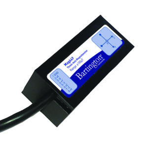
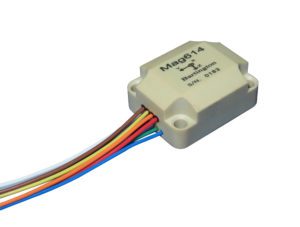
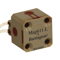
The high temperature and low noise sensors such as Mag610, Mag611 and Mag614 are ideal to measure AC or DC magnetic signals with the highest level of precision, ensuring extremely accurate positioning of the wells.
The active ranging method has application in the Oil & Gas industry (well intervention, SAGD), but has potential application in newer energy application such as Closed-loop geothermal energy generation.
The same method is also used for drilling operation in HDD typically used to perform river crossing. Typical sensors will include the Mag612/Mag619 for tool inclusion whilst the Mag-13 will be suitable for surface use.
Pipeline Inspection
For non-piggable pipelines, the use of magnetic tomography or stress induced magnetisation methods allow the user to detect defect by the stress they cause on the pipeline. The resulting magnetisation can be measured using very precise fluxgate sensors.
Low noise Mag-13 and low power sensors, Mag648 and Mag649 will all be suitable, with low power sensors more applicable to portable systems.
Directional Drilling
Steering of the drilling tools uses fluxgate magnetometer packages combined with accelerometers to determine the azimuth and dip of a well. The use of high precision sensors here reduces the directional errors of the drill string, optimizing recovery.
The high-temperature sensors (Mag610, Mag611 and Mag614) are well suited for integration in directional sensing tools.
Directional Drilling tool calibration
In order to achieve the best accuracy possible in drilling operations, directional tools need to be regularly calibrated to quantify sensor errors.
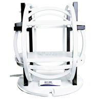
Using a low field Helmholtz coil system (HC1 or HC2) allow the user to generate DC and low frequency fields with an active compensation module reducing the effect of local disturbances on the coil’s stability.
Drill string magnetic hygiene
The presence of magnetic hot-spots on the drilling collars located near the directional tools will cause some localised errors. Collars should be inspected regularly to identify traces of magnetisation.
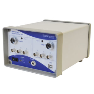
A suitable setup for these checks will include either some Mag-13MS with Spectramag-6 (multiple sensors enabling a faster scan) or handheld units such as the TFM1186 to detect hot spots.
In Field Referencing
During directional drilling operation, there are some occasions where increased accuracy is required.
One way to improve this is by having better knowledge of the local Earth’s magnetic field. Performing a declination and inclination survey over the planned well path will help reduce the survey errors.